The average temperature was 55.43F, which was 3.16F above our norm. For Raleigh, this November was the sixth warmest November on record. In fact, 19 out of 30 days were above normal. Both the maximum and minimum temperature were much above normal, too (1.8F and 4.53F, respectively). See Figure 1 for more details.
 |
| Fig. 1. November average temperature for KRDU. Data source: NCDC |
November precipitation was much above normal, too. The total precipitation for Raleigh was 7.14", which is 4.02" above the norm. November was the sixth wettest November on record. See Figure 2 for more details.
 |
| Fig. 2. Daily November precipitation totals for KRDU. Data source: NCDC |
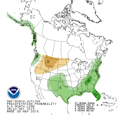
December will likely follow a similar trend. Most of the Southeastern U.S. is expected to experience above normal temperatures (figure 3) and above average precipitation (figure 4).
 |
| Fig. 3. One-month temperature outlook. Source: http://www.cpc.ncep.noaa.gov/products/predictions/30day/off15_temp.gif |
 |
| Fig. 4. One-month precipitation outlook. Source: http://www.cpc.ncep.noaa.gov/products/predictions/30day/off15_prcp.gif |
The above average precipitation is most likely in association with El Nino. As stated in the previous post, El Nino tends to enhance the subtropical jet, which causes storms to track across the Southeast. Inherently causing above average precipitation across the Southeast.
Overall, November was warm and wet. With a little help from El Nino, December will likely be a similar story.
No comments:
Post a Comment